, my son's birthday has passed, and the record cold rains of June (Brownie says coldest in 50 yrs.) have stopped, and the sun is out. This trip will be a major one of over 3,000 kms in 5+ days (no, it's not as far as Ms. E. Beard who went around the world by motorcycle 77,000km/48,000mi in 3 years).
I begin preparing by ordering a GPS, which turns out to be faulty, but Joe S. is nice enough to loan me his. As a backup, I copy and print out many google maps for the route. Since I'll be camping enough, I bought a new tent and did a test assembly on the front lawn, so there's no surprises on the road. I'm waiting to see when I will leave - based on the weather of course, and when my new order arrives of saddlebags and rear roll bag.
My bags arrived yesterday, the weather looks good, so I'm packed and ready to go this morning at 7:25am. The weather is sunny and 51°F/10°C as I head down familiar Hwy.11/17. The temperature dips to 46°F/8°C as I move inland and elevation rises around Dawsonville. Other than a little construction, this section is uneventful (other than enjoying rises/falls and twisties). At St. Leonard, I swing onto the divided Trans-Canada Highway #2 up to
where the GPS conveniently leads me to the Honda dealer. I'm looking for a rain suit and throttle rocker to help with my hand on the long trip. They don't have the rocker, and the suit is too thick and large for me to store in my bags, so I get directions to another bike place in the city. Unfortunately I head in the opposite direction that I'm supposed to, but eventually find Martin's Small Equipment. They have 2 throttle rocker models, so I get the better one, attach it in 1 minute, try it out, and like the feel. Since my longest ride previously was about 6 hrs., I hope to go longer with the throttle rocker attached.
After gassing up and appreciating the view while stopped on the Edmundston bridge (crossing the Madawaska River), I get back out on the highway where the temperature has risen to 60°F/16°C after the highway has turned into #185 as I cross into cloudy Quebec.
As I head further north, lots of construction is taking much longer to get through than expected. I begin to wonder if this is a sign of things to come, and hope to get to the other side of Montreal for my longest trip ever. As the road turns west onto #20 at Rivière-du-Loup, the mighty St. Lawrence river is now in view and construction has faded. The road is fast, but boring on a bike... I settle in behind someone who doesn't like the “100 Max” signs.
As I approach Levis/Quebec City, the rain starts. It's not wild rain, but enough for me to pull

under Exit 378 overpass at Montmagny for 10-15 mins. till it dies down. I decide to cover the roll bag with the rain protector, and even though it doesn't tie down, it fits snugly around the bag. Snugly isn't good enough I guess, since after leaving the overpass, the rain cover flies off in the wind. I hit the brakes and pull over, then start running back to where the cover is. Lots of traffic here, and the rain cover is blowing all around the lanes, but as I approach it, a truck passing by and blows it in my direction! I quickly snatch it and get back to the bike (the heck with the cover).
After more miles west, it's time to stretch out on the bike with feet on the passenger pegs and chin on the tank bag (which is filled with soft clothes). Being able to do this extends the miles I can put on before getting off the bike. I pass Trois-Rivière, and after more boring miles, I eventually approach Montreal. Before going through the city, it's time to get off at the final rest stop for a drink and snack (this is where the new bags come in handy, since I don't have to look for a store).
I soon leave the rest area for the city, and surprisingly, within 5 mins. the traffic has come to a stop! I expected this deeper in the city, but not this far out. It doesn't get much better..... stop and go traffic through many sections of construction, including a bikers enemy - grooved pavement. There's so much stop and go traffic, that by the middle of the city, my clutching wrist is getting sore. Later, I have to hook my fingers around the lever and pull with my arm. The temperature has climbed to 75°F/24°C, which is magnified in stop-and-go traffic.
While planning the trip, I considered other routes along the south of Montreal, and that seems like a late great alternative. Once I'm nearly through the city, the traffic speed picks up - good enough that I'm able to weave my way across the lanes - much easier than a car. Later, I realize that it's taken me an hour and a half to make it to the other side of Montreal! As I swing down Hwy.30, I see the dark clouds are rolling in, and rain is around the corner. Just in time, I duck under another overpass for shelter and rest. Someone in a convertible has the same idea as he gets his roof into place. Within 10 mins., I can leave again, and head for Ontario.
Another 20 mins. down the road I see my gas gauge flashing red to let me know it's soon time for a fill up. It's also supper time, and a storm is brewing. I take the first exit 825 (with gas sign), and then see an Ontario sign within the exit! I obviously missed the official Welcome sign awhile before (maybe due to construction?). Quebec was lonnnngggg to cross, so it’s good to see a new province (which I haven’t visited in ~33 yrs to visit another brother), and I take the opportunity to take a picture!
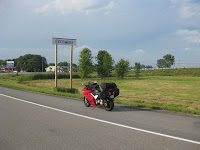
I cross the road and pull under the gas pump cover. After filling up and paying for gas, I see that this is the Curry Hill Truck stop just over the border, and is a good place to be hungry with the restaurant. I park the bike as a thunder storm begins, and go in the main building. I grab a small newspaper, sit down and am hungry enough for a turkey supper. I read about the Kiss concert in Ottawa (rich boys must need more money).
After wolfing down my meal that I had no trouble finishing (probably due to having no lunch), I see the storm has passed, so it's a good time to continue. Since I left Hwy. 401, I go up the parallel route Hwy.2 till the next exit at Lancaster. Now I'm able to go along the St. Lawrence river for some beautiful views and more interesting riding with turns! I stop along the route to take some community sign pics, and basically take my time. Cornwall is a nice
town, but surprised that the massive bridge for the first international crossing in Ontario dominates the western side of town.
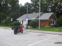
The day is getting late, and it's about 12 hrs. since I left home, so it's time to find a campground soon. After being in awe of the riches along this stretch of road with fancy houses, manicured lawns, and large boats everywhere, it's time to find a spot for the night. Finally, when I arrive in Johnstown (2nd international bridge crossing from Ontario to U.S.), I pass a nice looking campground, so swing around to come back. It's the
Grenville Park site, and the office is closed, but a note on the door shows me where to setup, and "checking in" can happen in the morning. This is a nicely setup site with playground, basic rides, a games room, etc. As I idle down a small hill, the view here is great, and I settle in to a beautiful spot by the water with
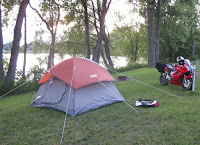
overhanging trees. I unpack and set up the tent easy enough, then immediately get the jeans off, and into some cooler shorts. I lie on the grass with bare feet and feel the cool breeze. Time to make a couple of phone calls to home and to check in with my brother for the following nights' stay.
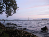
The sun is going down, and I go for a little walk down the road to get the biking bugs worked out of my tired body. Back at the campsite later, I take a few pictures around the lake and the international bridge in the background. It's early, but time for some sleep, which comes easy after riding the most kilometers ever in one day of almost
1000kms/12hrs...... Other than taking time back in Edmundston, I would've gone the extra 2 hours to reach Pete's, but I'm
exhausted!
Leg 2 : Johnstown to Sharbot Lake, ON (July 17, 2009 - 187kms)
After waking at 4am and hearing rain, I toss and turn on my crappy sleep pad until 5:30 when I hear the rain starting to ease. By 6:30am, I'm up, the rain has stopped, and the sun is breaking through, so I start by shaking water off the tent and fly.....then the same with the bike cover. The weather is getting nicer, and a light breeze, so I hang up my bike cover to dry better, along with the tent cover. After grabbing some trail mix and juice for breakfast, I take a walk around and up to the office to see if anyone is around for payment. The sign says it doesn't open till 9am! What traveler waits around that long in the morning before hitting the road?? I dismantle the tent, make sure everything is dry, and pack it up. I'm ready to go at 7:30, so leave the site, drive up to the office, and still no one around, so even though the gates are closed, it doesn't matter on the bike, since I slip between the 2 of them and out onto Hwy.2 again. I don't have very far to go today, but am on a slower road, and taking in the scenery and have a stop or two.
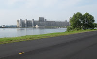
As I pass the Johnstown bridge to the U.S., I can't help but notice a massive concrete building with large white piles that are dwarfing the payloaders. Reminds me of gypsum, but who knows..... the building is huge and the sign says Port of Johnstown.
I stay on the old Hwy.2 up St. Lawrence River, go through the beautiful town of Brockville, and notice a Honda Powersport dealer. I pop in to see if they have some tools in stock that are specific to my bike. I find out they're a
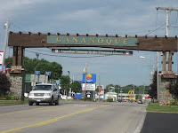
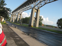
special order, so I leave for a larger Honda dealer in Kingston. Further up the road is Gananoque and the first thing I notice is Shoreline Casino, then, a nice square-arched entry to the town. I carry on to Kingston, and am met by an unknown huge green structure in the air. The traffic is stopped, and then I notice the flashing yellow light, and sign explaining to stop for lift bridge. Then I notice the boats leaving the marina with masts held high enough that requires the bridge clearance......what a strange setup to put the marina there!
I've got the GPS to guide me to the Honda dealer, and the first thing I notice, is I've turned right, then left - back to the original road I was on....guess the GPS was slower than my driving! I then find the proper road, get to the end of it, and the GPS tells me I've arrived, but I don't see it anywhere. I get my phone out to call the dealer, and they assure me that I'm on the right road, but to carry on a couple blocks after crossing a certain street. So after going in the opposite direction, I return to my original spot, and then realize the road takes a 90° turn. By going straight, the road turns into another name! Finally I find the place, and it seems to have everything in it - except for my tools. I can get them ordered in by Tuesday, but I'll be gone by then.
I leave Kingston, and make my way back out on the 401. I travel a few miles and find the Hwy.38 exit north through Glenvale and notice lots of lakes! . I come to a nice small town named Verona, and they are in festive mode by the looks of it. North of here I pass through Parham, Tichborne and the road is better quality and has some nice bends, and hills. It's 3pm when I pull into Sharbot Lake and find my brother waiting on the veranda. It's good to arrive, and after lubing the chain, I settle in for a cold beer, and the weekend.
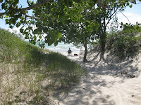 Side note : although I wasn't biking, I have to mention the weekend - it includes boating, fishing, beer swilling, band practice, and a day trip down to the Picton/Trenton areas where we reminisce at our old homes and schools. One MAJOR mention is the Sandbanks Park southwest of Picton (my included pic is best) - if you ever get a chance to visit, do it! This is one of, or THE best beach I've been to, and we were in awe!
Leg 3 : Sharbot Lake, ON to New York/Massachusets/Vermont/New Hampshire
Side note : although I wasn't biking, I have to mention the weekend - it includes boating, fishing, beer swilling, band practice, and a day trip down to the Picton/Trenton areas where we reminisce at our old homes and schools. One MAJOR mention is the Sandbanks Park southwest of Picton (my included pic is best) - if you ever get a chance to visit, do it! This is one of, or THE best beach I've been to, and we were in awe!
Leg 3 : Sharbot Lake, ON to New York/Massachusets/Vermont/New Hampshire (July 20, 2009 - 641 kms, plus 2 ferries)
The great weekend visit is over, and time to head out at 8:30am. It's sunny as I motor down Hwy.38 to Kingston. I drop into Canadian Tire and find a tent pad replacement - self inflating ooooh. I ditch my thin pad into a trailer outside the store, then pack the new one in the bag. I now need to exchange some Canadian money for $U.S., so I make my way down to King St. and drop into the swankiest bank I've been in! A fountain at the main entrance - money oozes out of every pore of this building. I end up paying $113 CAN for $100 U.S.
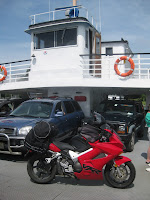
Leaving the bank, I try to find the ferry dock (which isn't obvious), but finally notice the sign and drive right by it. On the third attempt, I get the right road. I'm one of the early vehicles, and that's because the next ferry is 40 minutes away. I'm sure the Tim Horton's next door does some fine business from us people waiting.....so it's time for a tea and blueberry fritter mmmm.
Back in the parking lot, I'm talking to a CAA tow truck driver with rings coming out of almost every part of his head - he says he likes to be able to "express himself", and this is the job that allows it. He later notices my front tire and comments on the wear. I check it out, and yes, I could be making a pitstop during this trip (it turns out to be only 750km later).
It's 10:30, and the 55-car ferry has arrived to shuttle us 20 mins. across to Wolfe Island. Amazing how many sail boats are out on the water at the opening to Lake Ontario. Just as amazing is the number of wind turbines dotting Wolfe Island - doesn't look too good on a tourist island. I've heard that this island is the summer home to Don Cherry, and while on the ferry, I get talking to a guy who lives up the road from Don - who's involved in the community and has made a substantial donation to the community center project. "Substantial" to me and Don are worlds apart.
After docking on Wolfe Island, I'm first off the ferry, and it's not obvious where to turn, but ends up to be only a 10 minute drive to the south of the island to the next ferry. It turns out to be small - only a 6-car William Darrel ferry that goes to Cape Vincent, NY. After the short ferry trip #2, I soon see the customs shack ahead with one-man standing. It's a small place, but no small attitude on the part of the custom's officer eyeing me down as I approach. He asks for my passport, asks where I'm going, and do I have anything to claim. To my surprise, he doesn't ask me to remove my helmet but I confirm my ID with the photo in the passport. A 30 second conversation, and that's it! I hang a right and get on Hwy.12 through New York. I ignore the fast interstate down to Syracuse, and continue diagonally, staying on the same road down through Watertown, Boonville, and eventually into busy Utica (expansion place of Dunder Mifflin if you watch TV).
It's time to gas up for the first time in the U.S., so I'm interested in the
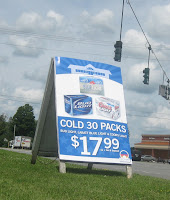
price difference. After seeing prices just below $1/litre in New Brunswick and Quebec, with a low of around 85¢/litre in Ontario, here in Utica, NY, it's about 70¢/litre. I push the bike over by the grass to sit down and have a snack and drink, and it's there that I see the REAL price difference in Canada/U.S. - it's a beer sign that shows an unbelievable price - $17.99 for 30 beer! I'm used to much cheaper beer in my area with Quebec about 40% cheaper than NB, but this New York price is ridiculously low.
I've had my rest, and it's time to get back on the road. I'm trying to stick to more interesting secondary roads, but will resort to interstates if I need to make up time, or don't have much alternative. The alternative excuse is the reason I get on it for the approx. 1 hr. ride from Utica to Schenectady on Interstate 90. I thought the U.S. speed limit was 55mph/90kph, so I'm surprised to see the 65mph signs, but makes sense on an interstate. Another thing that makes sense is the beautiful rest stops they have. I pull into one of these for lunch at McDonald's. There's a large air conditioned building with washrooms, games room, wireless internet, etc. A place where people can easily get off the highway for a better rest - a far cry from the ones in the Maritimes. Here I find that my cell phone doesn't connect to home, but I'm able to text message at least. When I gassed up in Utica, I also bought a NY map to check some confusing routes, and I wasn't totally trusting the borrowed GPS yet. I use this rest stop to map out the route I want to take around Albany, and decide on the north side of the city. Back out in the parking lot, I check my front tire again, and although it's worn quite a bit, I decide to go further (turns out to be about 600+ miles)
Back out on Interstate 90, I head to Schenectady area where I change over to secondary Hwy.7 (mainly to bypass Albany and most of Troy). I go out through Niskayuna and north side of Troy and get on Hwy.2 over to the northern part of Massachusetts. All I wanted to accomplish today was to get east of Albany/Troy, so things are going nicely.
Leaving New York, I continue on Hwy.2 east and cross into Massachusetts and of course take pictures of the border crossing. Soon, I take Hwy. 7 north, then east, I go through the top of Massachusetts (just below Vermont) through Williamstown.
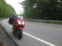
I'm faced with a drastic change in the road. I'm now in biker heaven with turn after turn, then I see caution signs for 4-mile inclines and declines. The elevation changes along with the
twisties make the next 16 mile ride very interesting!
I wonder how this road would've been with treads on my front tire ;)
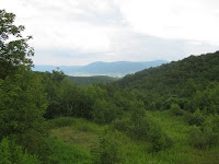
At the top of one mountain is a nice lookout, so I park the bike here for a better view, climb up on a rock and take a picture.
Another thing I notice on this route are the signs for "
truck runaways". I soon learn that these are located near the bottom of the mountain, and is an
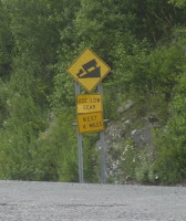
area for trucks that have brake failure. They can steer into an adjacent area filled with loose gravel, which has a braking effect when the truck hits it....ingenious.
At the end of the hills and twisties is Williamstown - "The Village Beautiful" as their sign states, and driving through I can see why. A really clean village, and nice old buildings. Although a village, it's home to a college and institute. Next door is North Adams, where I see that I can't gas up until I speak with the cashier and tell him how much. Well, I say, how do I know how to predict how much gas I'm going to take? He reassures me to just go ahead and gas up on tank #1 (66¢/litre). Afterwards, I try to pay, but the small-potatoes gambler ahead of me wants to buy every damn ticket in the place! I end up buying a drink and snack on more of the trail mix I brought from home. I fire up the VFR again after checking out the roads ahead to cut north across the states - staying away from the boring interstates.
I'm farther along on this leg of the trip than I expected, but I keep riding north on Hwy.8 across

the border into Vermont and the Green Mountain National Forest up to Searsburg. Here the road almost turns 180° onto Hwy. 9

and over to Marlboro. The last couple of hours has been the best ride on this leg, and it's getting later in the day, so as I pass through the final town of Vermont, which is Brattleboro and into New Hampshire, and it's time to take a break at a rest stop. It's a beautiful little spot with washrooms, covered picnic table among the trees, and a brook nearby. I'm kind of tired, and this place is very inviting as a campsite, but the sign says "no camping".
Even though I'd be long-gone in the morning before it reopens at 10am, I'm a law-abiding citizen, so I hop back on the bike and start thinking about camping for the night. I never thought I'd get much farther than Albany, NY, so being almost 200 kms further is a bonus, but I'm pushing it a little far since the sun is getting low. I was shooting for the other side of Concord, NH, but it's too late in the day. I queue up the GPS for nearby campsites, then aim for the one 5 kms. ahead. I come to the road sign pointing to the left for the campsite, so I follow the road up into the woods, which soon turns to dirt, and finally the GPS says that I've arrived. Well, there's no campsite here, so I continue further, turn around, go back, go up another adjacent road and repeat this again. I finally come to an area that looks like an abandoned site and wonder why the damn sign is still on the
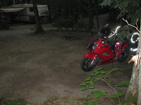
roadside. I go back out on the main road, and there's another site a few kms. ahead at Keyser Pond in Henniker, NH. I pull into the office site and it's getting dark. By the time I get to my spot, I need a flashlight to setup, and am not impressed by a cleared dirt spot. The mosquito's sure like me sweating and holding a light during this ordeal. After getting the tent/fly up and the bike covered, I jump in the tent, inflate the new sleep pad and find my ear plugs. It's only 9:30pm, kids are still playing around the campsite, so the plugs sure help drown out the noise, and I'm asleep very quick since it's been a 13 hour driving day!
Leg 4 : Concord, NH to Bar Harbor, ME (July 21, 2009 - 423 kms) I wake at 5:30 to get an early start, since a fella at the campsite office mentioned rain for the morning. Trying to pack before the rain begins, and luckily I'm able to and get on the road by 6am. Twenty minutes later after weaving through most of Concord, the rain starts, so for the second time this trip, I pull under an overpass to slip on my rain pants. After pulling out into it, the rain continues as I push along Hwy.202 past the last New Hamshire town of Rochester.
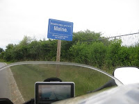
I cross the Maine border at Sanford, and the rain is slowing. It wasn't a hard rain, so my water-resistant lined jacket hasn't allowed me to get too wet. I keep the rain pants on as I continue northward and get on I-95 and I-295 up through Portland.....wow, I'm amazed at the traffic here. Now I'm seeing some nice coastal scenes reminiscent of home.
I leave the interstate again, as I'm now on another motorcycle haven - the Bluestar Memorial Hwy.1 along the east coast of Maine. As I enter Freeport, it's obviously geared to the shopper here, but I'm not interested. What they also have, is an excellent tourist office. I stop and the ol' guy inside is very helpful. After checking out the weather report on their computer, I explain to him I'll probably be staying at a motel in Bar Harbor tonight due to the rain forecast. So, he points out one that is only $58. Once outside, I realize it's warm and muggy, so time to lose the rain pants. There's also phone booths, yes, remember phone booths? outside, so I call the motel and make a reservation. It's still early in the day, and I should get to Bar Harbor early, so I head back out and take my time up the coastal road.
Immediately I notice all the lobster stands, and think of my brother 2 days before in northern Ontario crying that I never brought him any from the east coast. Well here, there's no shortage of the delicacy. Lots of nice small villages on this route, and surprised at another shopping location in Camden with its factory outlets and congested traffic.
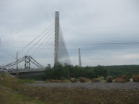
Further up Hwy.1 is Belfast where the road winds its way around the village, then onto Bucksport, Searsport and then the awesome new cable-stayed
bridge. The Penobscot Narrows Bridge & Observatory crosses over the Penobscott River to Verona Island (which was featured in Popular Science magazine as one of the 100 best innovations of 2006).
Another shopper's surprise is at Ellsworth where I gas up (approx. 65¢/litre), then change roads south on #3 to Trenton (with enough Acadia presence here), and finally onto Mt. Desert Island with Bar Harbor. Since entering New Hampshire, I've been seeing the odd biker without a helmet, and see it again here in Maine, so the last mile I ride in Bar Harbor, I pull over, take my helmet off, and ride the rest of way - which feels AWESOME at the end of the day!
I find
Robbin's Motel and sign in. My intent was to stay at Acadia National Park campsite, but the 100% rain forecast doesn't have me interested in packing up in it. It's a small quiet cheap motel, but after lubing the chain, I immediately take advantage of the shower. Earlier, I pushed my bike over to my room instead of driving, and the helmet fell off the seat and the visor goes flying. A Quebec biker next door offers me a cold beer and tools that take up much of his trailer. He makes a joke after realizing that I had no tools and was driving a Honda. He had a Harley and always carried tools. A nice guy, and before long I have the visor fixed up and back on the helmet. I take this time to check my front tire, and see it's badly worn, so I plan to change it after getting to Nova Scotia.
After getting cleaned up and unpacked, I take a ride down the road to see where the Cat ferry dock is, and make a reservation, then back up to the Acadia Snack Shack for a crab roll supper. Back at the motel, I don't last long after the late supper and watching some TV.....I'm crashing fast, and sleep comes quick again (just as farmers must sleep)
Leg 5 : Bar Harbor, ME to Greenwood, NS via ferry (July 23, 2009 - 386 kms)
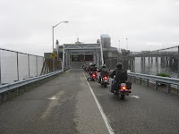
I set my alarm for 6:30am, but am awake 1/2 hour early. I take my time packing up, and head down to the Bar Harbor (US) Ferry Terminal 20 mins. early. There's already a bunch of cars through the gates, and after checking my paperwork, I'm sent over by other motorbikes.
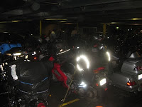
I get talking to a couple from Indiana, and a couple from Nova Scotia. This guy has been all over on his bike - even over to Vietnam to bike for 5 days! Over the next 45 mins. all the bikers compare notes and stories, and by boarding time, there must be 40 of us. Inside the ferry, we are sandwiched together and instructed to strap our bikes down to the floor anchors. We all

make our way up onto the upper deck, but unfortunately it's a foggy day, and we can't see too much. On the rear deck, I can see us leaving the dock, and the wake starting to pick up!. This is one powerful
ship - reaches speeds up to 90kph and has minimal rocking motion.

After settling in, it's time for breakfast, and an expected expensive egg/bacon breakfast sandwich and cup of tea, but it sure hits the spot! As we begin crossing the Gulf of Maine, I soon meet another biker - a stereotypical Harley rider with cut-off sleeves to broadcast his tattoos running up and down his arms. We are sitting at the front observation deck and I soon learn that he is a retired U.S. marine from Tennessee who had 2 tours of duty to Vietnam and then later to the Gulf War in Iraq. He's since moved to a quieter Bangor, ME and spends his spare time riding his Harley.
Needing to get away from the noisy fog horn at the front that regularly blasts, I'm back on the rear deck of the ship where the full power can be seen and heard. It's refreshing back here, and am realizing that my trip is soon going to be over. Unfortunately the weather forecast is not great, and I'm expecting rain when I get off the ferry at Yarmouth. The 3 hour ride slips by, and we are exiting the ferry. After reaching customs, I'm questioned about my whereabouts, and the $45 that I'm claiming - one being a duty-free bottle of Jack Daniels from the ferry for $21. It's no big interrogation, and soon I'm off through the nice town of Yarmouth in the heavy fog and light drizzle. I make a phone call to the Honda dealer in Kingston about a new tire, but I'm on hold too long and have no patience after 5 mins., so I'm back on the bike again heading up Hwy.101. The weather is not great, as I continually wipe the moisture off my visor, and I sure can tell I'm driving in a coastal province since the wind has picked up. The road is wet, so I'm extra careful with the state of my front tire.
At Annapolis Royal, I leave the main road for the older, more scenic Hwy.1 up the Annapolis Valley. This brings back old memories of when I lived here growing up. It's a slower route, but like most of this trip, I've stayed away from the big highways and interstates since I want to SEE where I'm going. By the time I get to Paradise, NS, the rain has stopped and the first blue patch of sky shows itself and I can't think of a better reason why it has that name!
I'm soon rolling into Greenwood mid-afternoon, and find my sister home to greet me. While here, I contact ProCycle in Halifax to arrange a front tire replacement tomorrow morning. They make a spot for me since I'm travelling.
After spending a great evening/night visiting, it’s time to crash....
Leg 6 : Greenwood, NS to Home (July 24, 2009 - 709 kms)
Awake for my last leg of the trip, I realize it's a long one at approx. 8 hrs, but longer with the stops I will make. I'm off at 8:30am, and the weather is overcast and 60°F/16°C and wanting to rain as I get to the gas station in Kingston to fill up at "normal" prices. Back out on Hwy.101, there's intermittent light rain, but nothing to be concerned about. It's windy, and as I cross the rivers at Wolfville and
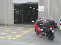
Windsor, I see the familar effects of the Bay of Fundy - low tide and mud flats. The road lanes increase soon after, and traffic is moving better - right down into Dartmouth where I find
ProCycle. I'm right on time for my 10am appointment, and as I browse around the well-stocked store, the front tire is replaced in 45 mins. They assure me that it's also been road tested which impresses me (I can see why they have many award plaques on the walls)..... I'll certainly return here in the future.
Weaving out of Dartmouth, I can feel an immediate huge difference with my steering. Even though the wind is strong, the new tire is having a drastic effect - I'm cutting around turns with no effort at all. After getting out onto Hwy.102 north, it's time to get into relax mode by laying down on the bike again. This section of highway is uneventful, but the weather has cleared nicely, as I take the first exit and find my way to my mother's house at the top of the world for lunch, tea, and a 3+ hour visit.
It's a beautiful day as I leave Springhill on Hwy.2 north, and I'm really noticing the new tire's ability here with many more turns. In 20 mins. at Amherst, I'm back out on the Trans-Canada Hwy., and even though it's windy, I have no trouble going across the extra-windy border section due to the new tire. Before long I'm coming into Moncton - where I'd normally take the shortcut through Scoudouc and up the NB coast, but today I'm leaning to the quicker road on Hwy.126. Unfortunately the first thing I come to is construction - which has slowed traffic to a stop. Once it gets moving, everyone is merging into one lane on the newly paved road, and I'm wondering why, since the pave is still 2 lanes wide. I look up the right lane, see nothing, so motor on past ~50 cars before the lane merge sign appears. Construction soon clears, and I'm rounding Moncton, up to the Magnetic Hill exit, around Lyons Country Store and onto #126 north. Another great road (with its many turns on the north and south sections) to see the effects of the new tire.
Traffic moves along nicely through this road, and after gassing up, I cross over the Centennial Bridge at Miramichi, and continue on Hwy.8 north. Another fast-moving highway, a sports car wants to play cat-and-mouse with me, but with lots of luggage aboard, and him not standing a chance, I let him pass and lead the way.
At Bathurst, I swing onto Hwy.11 north which I think I can drive with my eyes closed, so time to stretch out on the bike with chin on tank bag again. At this point, I know home is near, and after a long trip, I'm just interested in getting there. It's been an amazing week with many new places, and familiar faces I haven't seen in a while, but nice to roll into the driveway after 3300kms. and be greeted by Donna, Jeff and the dogs at 8pm.
 I was keeping my eyes on the weather reports for a few days leading up to launch date, and it was looking like Nova Scotia would get the major part of the storm, and not us. I was scanning the weather reports from the east and west sides of the province, just to make sure I had the right route with little or no rain. On this day, the weather cooperates, and I can take the shorter route along the east side of the province. The weather window of opportunity was at 3pm, so I headed out under overcast skies, and a comfy 68°F/20°C.

 driving - not that easy. I'm at least able to take a couple movies along the way, and they turn out half decent. Continuing north on Hwy.165, I'm amazed at how close and high the river is.... understandable how this area would easily flood in the spring. But, for now, it's summer, and the thermometer has bumped up a couple degress to 75°F/24°C, and the sun continues to shine! We make our way through the nice town of Woodstock where the Meduxnekeag and Saint John Rivers meet .
 key on with the lights sucking the power out of the battery. Enough so, that the bike won't start. Luckily, there's a little more downhill for me to jump-start the bike before the bridge. This is a single-lane bridge, so after waiting for oncoming traffic to get through, it's our turn to cross. I follow Kirks' rumbling exhaust (ya, a tad louder inside the structure), as I hold the camera above the fairing in video mode. Now I know where they got the phrase "light at the end of the tunnel" as we exit into bright daylight again.
 We head back up the hill, follow the Aroostook River, and take the exit, where Kirk pulls over. He's gone far enough, and it's time to go our own ways. After saying goodbyes, he turns back south, and I continue north on the old T.C.H. which runs parallel to the new 4-laner through Four Falls. This leads me right into Grand Falls, where I find the downtown core which has the magnificent Grand Falls gorge and dam. The main street is divided by a wide medium with trees, benches and sidewalk. This is a beautiful town that I plan to revisit.


